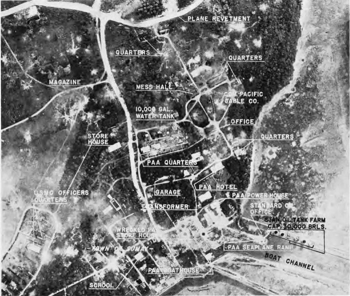
NAVY PHOTO INTERPRETERS have annotated this vertical view showing the ruins of the town of Sumay, PAA sea plane base, Marine reservation and the beginning of the airfield built by the Japs. Most of the structures in the seaplane area have been shattered completely and planes have been blasted here and on airfield taxiways above. This base was formerly an important stopover for planes bound from the United States to the Orient.
Guam is the crossroads of two lines of stepping stones across the Pacific-the Japan line, south from Japan through the Bonins, Marianas and Carolines to the Equator; and the American line from San Francisco to China via Hawaii, Midway, Wake Guam and the Philippines.
The island is important chiefly because of large land areas suitable for major air bases and its location in direct line of communications between the Japanese Empire in the north and the mandated islands. It is approximately the same distance from the Marshalls, Philippines and Tokyo. In 1940 the population of Guam was 23,067 including 21,502 natives, 787 non-native residents and families, 778 naval personnel. Only 39 Japs were recorded on the island, and Japanese influence was not strong, though Rota, under Jap mandate, is only 45 miles away. The population was concentrated around the harbor of Apra on Orote Peninsula.
THE CAPITAL CITY of Agana was an attractive town of 12,000 with many comfortable-looking lime and coral rock houses, prosperous stores and clean streets, a modern sewage system and electric plant. This town was the social, economic and religious center of Guam, with administrative and judiciary buildings, a cathedral, high school and the main office of the Development Bureau. The town of Sumay is next in size and importance, and is also located on Apra Harbor, on Orote Peninsula. Here also is one of the major airfields of the island, as well as the seaplane base. Another important airfield is located nearer the center of the island, in the vicinity of the town of Agana. Both these airfields were constructed entirely by the Japs.
The southern half of Guam is volcanic and hilly, rising to a height of 1,334 feet, but the northern half is a broad reef-limestone plateau which offers many additional sites suitable for airfields which can be used against the Jap mainland.