The very eye of typhoon Karen rolled over Guam during the late evening hours of Sunday, November 11, packing sustained winds of 150 knots. Gusts to 207 miles an hour were reported which left in their wake nine dead, hundreds injured, 9,000 civilians homeless, and damage estimated in excess of two hundred million dollars.
Guam, lying in the typhoon belt of the Pacific Ocean, has had to learn to live with the ever-present danger of these monsters. Because this danger exists, military and civilian planners long ago established a series of four typhoon conditions. The island is normally in Typhoon Condition Four which means typhoon winds are possible within 72 hours. Winds of 64 knots and up are considered to be of typhoon force
The 32 mile-long island was in Condition Four, and a long Veteran's Day weekend was being planned by most Navy-men and their families that second week of November.
Typhoon Condition Four
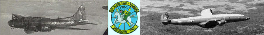
Fleet Weather Central/Joint Typhoon Warning Center first began tracking what was to grow to typhoon Karen November 6 when the Truk-Ponape area was declared a suspect zone. Meteorological information gathered indicated a possible low pressure area in that zone. Aerial surveillance by the Navy's airborne Early Warning Squadron One and the Air Force 54th Weather Reconnaissance Squadron began.
Just two days later a swirling mass of rain, wind and clouds was dubbed typhoon Karen. Aerial surveillance continued as Karen staggered generally northward, steadily gaining in strength.
Typhoon Condition Three
Karen was moving northward at five knots with internal winds of 150 knots and was still 520 miles east southeast of Guam when Commander Naval Forces Marianas, RADM John S. Coye, Jr., ordered the setting of Typhoon Condition Three.
Eyes were cast upward for the first clues of an impending typhoon as white-hats went about the preparation tasks of setting Typhoon Condition Three. Emergency supplies were checked, water and gasoline tanks were filled to capacity, housewives checked their stocks of food, and ships began requisitioning emergency supplies
Karen continued her slow march northward without an indication of moving westward away from the Mariana Islands. For two days she moved along at 5 knots and then abruptly began to pick up speed across the water. At 2100 Saturday, November 10 the order went out to set Typhoon Condition Two.
Typhoon Condition Two
At 0400 Sunday morning Karen was located 300 miles east southeast of Guam and moving west northwest.
Windows and doors were boarded over, emergency rations were distributed to command posts, medical supplies were readied, vehicles were gassed and marked "Typhoon Emergency." Television antennas were brought down, yard furniture and children's toys were inside, the civilian population continued their preparations for the coming typhoon.
Typhoon Condition Two sent emergency manning crews to their station at all island command posts while Karen continued to churn the sea throughout the night, moving steadily in a west northwesterly direction at six knots.
At 0800 Sunday the order went out to set "Typhoon Condition One."
Typhoon Condition One
Karen was 200 miles from Guam as the radar picket escort destroyers Haverfield and Brister cleared the breakwater to outrun Karen's winds. They were followed by the fleet tug Wandank and light cargo ship, Banner. All naval activities made their last minute inspections to be certain all was secure in expectation of Karen's 150 knot winds.
Fleet Weather Central/Joint Typhoon Warning Center continued to issue public warnings concerning the progress of the typhoon as she rolled to 190 miles east southeast of the island.
Land radar stations took up the vigilance on Karen. By 1600 she was 81 miles east of the island, tracking west at 14 knots and locked on her target of Guam.
Predictions from Fleet Weather Central/Joint Typhoon Warning Center indicated the island would be subjected to the very eye of typhoon Karen. The eye was predicted to pass directly over Guam sometime between 2100 and 2300 Sunday night
People were ordered to evacuate the low-lying village areas on the east coast since a storm surge of six to ten feet above high tide. This would bring high waves directly over the sandy beaches into residential areas to many villages.
By 1900 winds were gusting to 70 knots in some portions of the island. Families were forced to leave their homes for more protection as chunks of roofing material were ripped from house tops and sent spiraling through the air to smash other homes.
Winds increased to 92 knots and still the full force of the typhoon's power had not reached the island.
Tug boats in Apra Harbor snapped their moorings as mountain seas pounded the hulls against dock-sides. Pier bulk-heads broke under the pressure, leaving exposed bolts to smash into thin-skinned harbor craft.
Wind-whipped storm surges rolled over reefs thundered ashore, smashed into homes and public buildings, and then retired back to the seas with a load of twisted sheet metal and fragments of wood.
Damage reports began trickling into headquarters of Commander Naval Forces Marianas as winds reached the 100-knot mark. Antennas began buckling, coconut palms snapped, exposed ridges were stripped of all vegetation, and whole homes were blasted by the explosive force of the wind.
At 2145 wind speed indicators at Fleet Weather Central/Joint Typhoon Warning Center bounced over the 135-knot mark as the men prepared to evacuate the building. Communications ground to the very minimum between military commands scattered along the islands entire 32 mile length. Transmission and receiving antennas were ripped loose by the powerful wind fingers of typhoon Karen and still the highest winds had not been reached.
Estimates of the possible number killed began to rise as reports of roof tops landing on the main roads were relayed to the headquarters building.
A report that the eye of the typhoon had passed over the Naval Air Station at 2210 proved false. The wind speed indicator at the station was touching 150 knots and then fell to zero. It was later determined that the wind instrument was torn from its mooring at that speed.
Rocks and bits of coral shattered hundreds of glass panels on the western side of the Naval Hospital.
Headquarters personnel learned that two firemen had attempted to cross the 100-yard open stretch of ground between Station Five and the headquarters building. It was five hours later that they were reported safe. They had started to leave the structure as whole sections of the roof were wrenched free, but just as they were about to leave the building began to collapse. They dived beneath a fire truck in time to prevent their being crushed. Later they worked their way into the relative safety of the cab of the truck.
Others were less fortunate. A pregnant Guamanian woman was crushed by the roof her home; three men were crushed by the buckling wall of a downtown business establishment. The building was just 30 yards from the water's edge and throughout the night was subjected to the pounding surf.
At first light the island resembled the hours immediately following the pre-invasion bombardment laid down by American forces in July, 1944. Comfortable villages were now a blasted, battered shambles. Sheets of corrugated metal, a popular roofing material, were everywhere. The metal was formed around trees, fire hydrants, across utility wires, over autos, and strewn across the terrain. Utility poles hung at fantastic angles, wires littered the roadways, eight inches of sand and coral covered Marine Drive in Agana. The heavily populated villages of Sinajana and Agana Heights were leveled.
Eighty percent of the Ship Repair Facility buildings suffered moderate to severe damage. BOQ's on Nimitz Hill were wrenched from their moorings and laid open. The expansive Navy Public Works Center suffered minor to major damage in most of their buildings. Officer and enlisted housing damage ranged from slight to severe. Wives told of a horror-filled night of erupting windows and flying debris.
Ninety-five percent of all civilian homes were destroyed, 9,000 people were left homeless, three ship were sunk, two tug boats and a huge floating crane were driven aground, and all Naval activities reported heavy losses.
One week after Karen's passing nine confirmed dead were counted as a direct result of her power.
Twenty-four hours had passed since the order went out to set "Typhoon Condition One." And the island had returned once more to "Typhoon Condition Four."