The year 1962 was only the second typhoon season that VW-1 had this assigned weather mission tasking. This, of course, was long before the advent of the weather satellite. The typhoon season was from June through December, but typhoons could, and did occur at other times in between. The Joint Typhoon Warning Center (JTWC) required four fixes per day on a full fledged and named typhoon. The Air Force made the two-daylight fixes in WB-50's and the Navy (VW-1) would make the two-night fixes. The normal procedure for VW-1 to determine the location of a typhoon was with a radar fix from a point near the storm.
 The Navigator could navigate using Radar, Loran, Radio Direction Finding or
Celestial. This position also controlled the radar ground stabilization equipment (APA-57) and the
Central Gyro Reference System (CGRS). The CGRS was used to stabilize the radar antennas as the aircraft
attitude was changed.
The Navigator could navigate using Radar, Loran, Radio Direction Finding or
Celestial. This position also controlled the radar ground stabilization equipment (APA-57) and the
Central Gyro Reference System (CGRS). The CGRS was used to stabilize the radar antennas as the aircraft
attitude was changed.Photo Lyle Fisher.
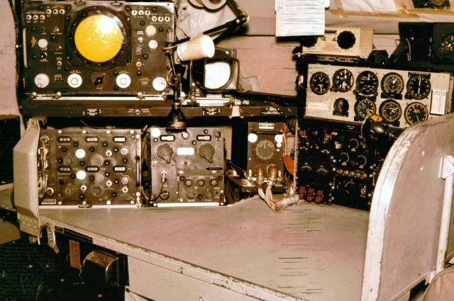
 The CIC/Wx officers position was immediately aft of the radar technicians position.
The instrument on the left measured the barometric pressure, the instrument immediately to the left with
the yellow inspection sticker was commonly called "the Green Worm" because of its color and circular
display with a couple of squiggles in it. It measured the radar altitude of the aircraft. The black box
to the left of the cigar box is the AMQ-8 weather recorder, recording the temperature and humidity
outside the aircraft.
The CIC/Wx officers position was immediately aft of the radar technicians position.
The instrument on the left measured the barometric pressure, the instrument immediately to the left with
the yellow inspection sticker was commonly called "the Green Worm" because of its color and circular
display with a couple of squiggles in it. It measured the radar altitude of the aircraft. The black box
to the left of the cigar box is the AMQ-8 weather recorder, recording the temperature and humidity
outside the aircraft.Photo Doug Pendray
The first year that VW-1 performed the typhoon-tracking mission, the squadron nearly lost two aircraft doing nighttime penetrations of large typhoons (150 knot winds). These penetrations were flown at an altitude of 1500 feet. The second year, the policy was changed. Large typhoons would not be penetrated at low altitude at all. Storms of the 100 to 125 knot variety could be penetrated at low altitude but only during daylight hours.
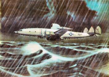
VW-1 flight crews could accurately determine the location of a typhoon using the APS-20 radar and a Navigator provided aircraft position. The only way to obtain and record the barometric pressure in the eye and determine the wind speed in the outer wall clouds was to fly into the eye of the typhoon. The barometric pressure within the eye of the typhoon was an important factor for evaluating the intensity or the order-of-magnitude of that typhoon. The determination of wind speed could only be made while maintaining visual contact with the ocean surface. Visual contact with the water could normally be maintained by flying at an altitude of about 300 feet.
 Flight crews were provided pictures that showed the appearance of the sea surface at
various wind speeds. The appearance of the ocean surface with 100 knots of wind from an altitude of 300
feet is truly an impressive and awesome sight.
Flight crews were provided pictures that showed the appearance of the sea surface at
various wind speeds. The appearance of the ocean surface with 100 knots of wind from an altitude of 300
feet is truly an impressive and awesome sight.Photo of Japanesse Silk Painting.
Accurate true altitude determination was a vital factor for low altitude typhoon penetrations. All VW-1 WV-2's (EC-121K) had a very old (World War II vintage), but highly accurate SCR-718 radar altimeter mounted at the CIC Officer position. It was known as the "Green Worm" because of its unique display. The display was a "J" type cathode ray tube with a circular trace. The faceplate of the display was calibrated in feet. The altitude was determined by setting the leading edge of the transmit pulse to "zero" feet, on the faceplate scale and reading the leading edge of the ground or surface return pulse using the same scale, this provided the aircraft's true altitude above the surface. The SCR-718 had two scales, low up to 5000 feet and high up to 50,000 feet. During a typhoon penetration at low altitude, one of the Aerographers would constantly monitor the altitude on the SCR-718 and report directly to the cockpit over the ICS with a "hot" microphone.
The wind velocity in the wall clouds of a typhoon was determined by the appearance of the surface of the water". Flight crews were provided picture books that showed the appearance of various surface conditions and associated wind velocities. The appearance of the ocean surface with 100 knots of wind from an altitude of 300 feet is an impressive and awesome sight.
The wind velocity in the wall clouds of a typhoon was determined by the The shortest distance into the eye of the typhoon is directly across the wall clouds of the feeder bands, or 90 degrees to the wind direction of travel. One hundred knots of winds that is 90 degrees off the direction of travel will cause the aircraft to have a drift angle of about 45 degrees. The drift angle could be verified with the Navigator's drift sight. This drift was also readily apparent and obvious when just looking at the surface of the water from a window. Once in the eye, the surface wind would go to light and variable with not a "white-cap" seen (first white-cap seen indicates wind of 8 knots).
The squadron's standard operating procedure for typhoon tracking fixes was to launch (take-off) in time to just reach the storm to make the first required fix. The crew would then setup race-track pattern away from the storm, reduce power to conserve fuel and, wait and watch the storm for the next six hours, until time for the second required fix. By the time of the second fix a probable track (direction of movement) and speed of the storm might be determined. Once the second fix was made, the crew would return to base.
Typhoon Karen
 Fleet Weather Central/Joint Typhoon Warning Center first began tracking what was to
grow to typhoon Karen on Nov. 6 1962 when the Truk Ponape was declared a suspect zone. Just two days
later a swirling mass of rain, winds and clouds was dubbed Typhoon Karen. Aerial survaliance continued
as Karen staggard generally northward, steadily gaining strength.
Fleet Weather Central/Joint Typhoon Warning Center first began tracking what was to
grow to typhoon Karen on Nov. 6 1962 when the Truk Ponape was declared a suspect zone. Just two days
later a swirling mass of rain, winds and clouds was dubbed Typhoon Karen. Aerial survaliance continued
as Karen staggard generally northward, steadily gaining strength.Photo VW-1
In early 1962 the rumor was that Guam was never hit by typhoons at least not since VW-1 moved to Guam in 1957. The accepted rumor at that time was, since Guam was down there where typhoons formed, the storms went by Guam before they got big or fully developed. In November of 1962 all of this changed forever.
In November of 1962 Crew 2 with TE-2 had been operating out of Sangley Point Naval Station in the Philippines. Crew-2 was tracking a typhoon through the South China Sea. The storm was approaching the shore of Mainland China, so VW-1 services were no longer required. The plan was to return to Guam the next day. Upon arrival back at Sangley after that last mission, it was learned that the return to Guam would be delayed a day since another storm was in the area of Guam. The storm was forecast to turn to a more north-easterly direction and pass well to the north of Guam. The next day the crew learned the storm had not turned yet, but would, and there would be another day delay. The following day Crew 2 learned that the typhoon, called Karen, was still bearing down on Guam, but was still forecast to pass to the north of the island. The other crews and aircraft left on Guam began flying out to NAF Naha, Okinawa, and NAS Atsugi, Japan. Crew 2 learned that Typhoon Karen was a major typhoon.
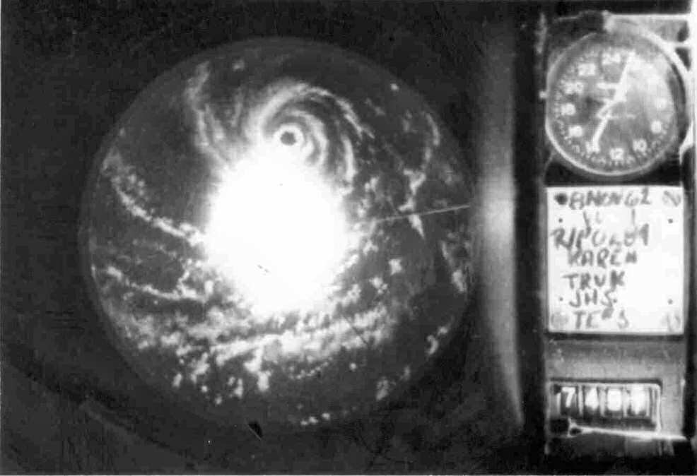
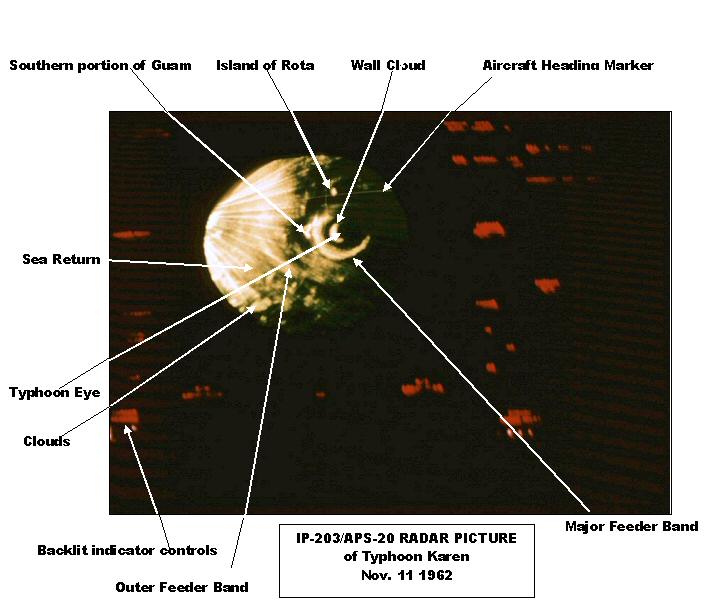 Photo of Typhoon Karen taken with a hand held 35mm camera.
Photo Lyle Fisher.
Crew 2 was tasked with making a single radar fix on Karen that night as the storm approached Guam and then return to Sangley. Karen was still forecast to pass to the north of Guam. Due to the round-trip flight time involved, about 13 or 14 hours, Crew 2 would only stay in the vicinity of Guam long enough to make the one radar fix before turning back to Sangley. Crew 2 arrived that evening in the area of Guam to find one of the major feeder bands of Karen over Guam. It was obvious from the radar picture the worst of the storm was yet to hit Guam. The First Radar Tech on Crew 2 took hand-held time exposure pictures of the IP-203/APS-20 radar display with a 35-mm camera using color slide film. TE-2 was about 90 nautical miles from Guam at that time and at an altitude of about 10,000 feet. The front-end crew attempted to make radio contact with Guam. The only contact that could be raised was with NAS Agana Ground Control. Ground Control was receiving winds of 100 knots at that time. Soon after that all contact was lost. Crew 2 returned to Sangley and waited for word. The following afternoon was the first news that Crew 2 got from Guam. The crew learned, "there were no military dependents killed". No word on injuries, possible damage or anything else. Crew 2 had to wait another 3 days before the runways were cleared of debris, fuel storage was checked for contamination and enough power was regained to pump fuel before TE-2 was allowed to return to Guam.
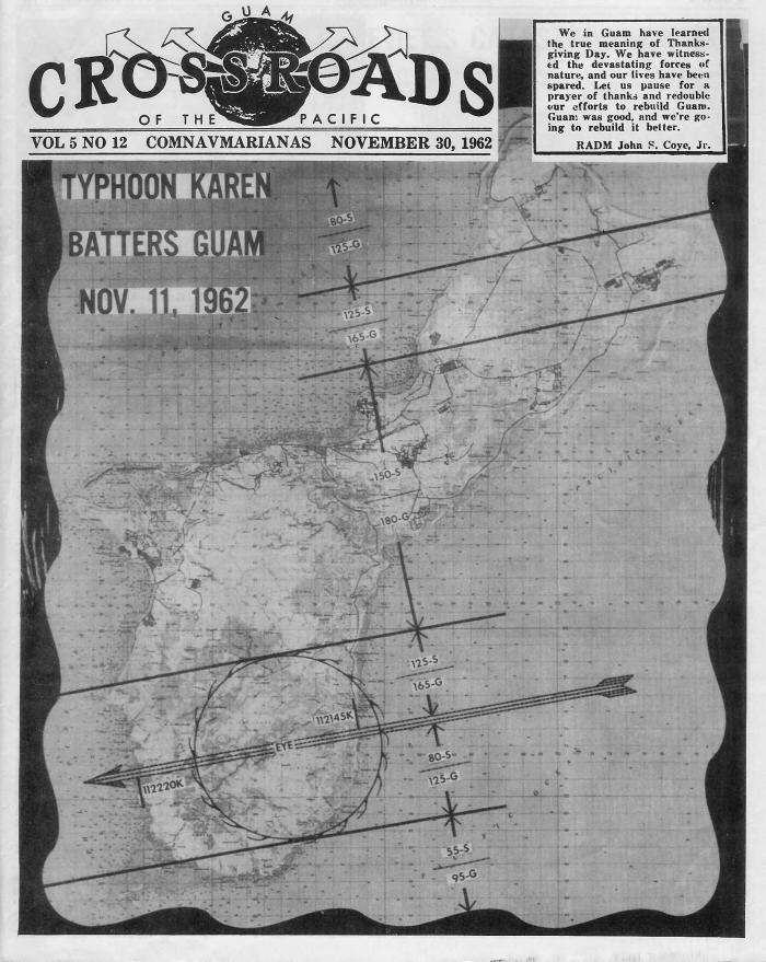 The path Typhoon Karen took as she crossed Guam Sunday, Novemeber 11th.
"S" stands for sustained winds, "G" for gusts. 112145K indicates that the typhoon touched the island at
9:45pm and 112220K that it had completed its passage at 10:20pm.
The path Typhoon Karen took as she crossed Guam Sunday, Novemeber 11th.
"S" stands for sustained winds, "G" for gusts. 112145K indicates that the typhoon touched the island at
9:45pm and 112220K that it had completed its passage at 10:20pm.Photo by Otto Gnrich PH3, of the COMNAVMAR Photo Lab.
The first sight of Guam was almost unbelievable. Guam, the lush green, tropical island was no longer green. Guam now looked like New England in the winter, nothing green. The damage and destruction was beyond description and comprehension. The only structures that survived total destruction were constructed completely of concrete, including a concrete roof. Government housing was all-concrete, except no storm shutters for the windows were provided. Some government housing units had windows blown out front and back which allowed for much water damage throughout the unit and a coating of grass and leaves over all interior walls. After the storm, at NAS Agana, the water was off for two days, the electricity was off for nine days, and the phones were out for three weeks. For a number of days after Typhoon Karen the enlisted galley at NAS Agana was open for three meals a day to all military and military dependents.
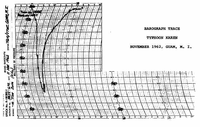 FWC/JTWC barograph chart of Typhoon Karen as she passed over the island on 11
November 1962
FWC/JTWC barograph chart of Typhoon Karen as she passed over the island on 11
November 1962
The final statistics on Typhoon Karen were awesome. Karen had sustained winds of 155 knots with gusts to 180 knots (207 mph). The barometric pressure recorded in the eye as it passed over the island was thought to be one of the lowest sea level barometric pressures ever recorded at something like 27.7 inches of mercury. It was said that when the eye of Karen passed that the pressure dropped so suddenly that the air in the sink drains could be heard rushing out. Fortunately, Karen was small in physical size and moving fairly fast at 15 knots, which probably avoided additional destruction. Karen, while still 500 miles southeast of Guam and tracking north-northeast, made a 90-degree left turn and traveled in almost a straight line for 500 miles. The eye of Karen passed directly over the middle of Guam. Twelve years later, people on Guam still spoke of "Typhoon Karen".
The 35 mm time exposure pictures taken of Karen from the IP203/APS-20 display turned out far better than expected and were considerably better than any others that were taken at the time. The pictures were shown to the Crew 2 Weather Officer who wanted copies and would make them official Navy photos. In the 1963 special Typhoon Karen issue of the Glimpses of Guam magazine the Typhoon Karen radar picture was published (unfortunately, upside down).
At the end of the 1962 typhoon season the average error in predicting the future (24-hour) movement/location of a typhoon was off by 120 nautical miles. Predicting the movement and location of a typhoon 24 hours into the future, remains an in-exact science.