ALTHOUGH NOBODY has yet been able to do much about the weather, there are people who can tell what kind is in store-and do a great deal about that. Strategically based not far from the area where many typhoons are born is the United States Fleet Weather Central/ Joint Typhoon Warning Center, Guam, a naval command under the Commander-in- Chief, Pacific Fleet.
The Navy and Air Force meteorologists working here cannot stop the terrific storms that boil up in the western Pacific, but they do watch, and warn. These warnings permit military and civilian authorities throughout the area to ready their facilities for weather that may soon become hazardous to life and property.
The command is unique in that it is the only military command that combines the functions of a Fleet Weather Central, a U. S. Weather Bureau, and a joint command (Joint Typhoon Warning Center). Fleet Weather Central, Guam, operates as a naval activity, while the Joint Typhoon Warning Center is under the direction of an Air Force officer. Working under one roof, they provide services which complement each other.
FWC analyzes weather information and makes forecasts and warnings within the Pacific Ocean area west of 160 degrees, east longitude and extending south below Australia and north to 80 degrees north latitude above the Asian mainland. It also disseminates routine weather information for the public and government of Guam (normally a function of the U. S. Weather Bureau), and the Trust Territory Islands. Meteorological support for Commander Naval Forces, Marianas, and oceanographic services for U. S. armed services are other duties of Fwc.
In support of the Seventh Fleet and other naval units, FWC broadcasts routine weather forecasts and issues wind warnings and special forecasts as required. Facsimile broadcasts (the transmission of weather maps, charts, photographs) are also made regularly.
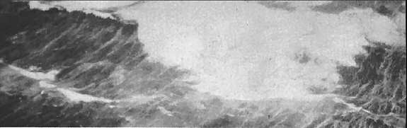
 AG's track storm from plane.
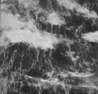
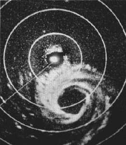 Cyclone photographed on scope
In June, direct readout equipment was installed, to make it possible for FWC, Guam, to obtain information from the Nimbus weather satellites. Nimbus will provide the FWC with a much-needed weather eye over the entire Pacific.
THE JOINT TYPHOON Warning Center does just what its title implies. It issues tropical cyclone warnings to all U. S. government agencies within its area of responsibility. This area varies from that of FWC, extending from the international dateline on the east to the Asian coastline on the west, and south to the equator. Included in the center's duties are tropical cyclone research and preparation and distribution of the annual typhoon report.
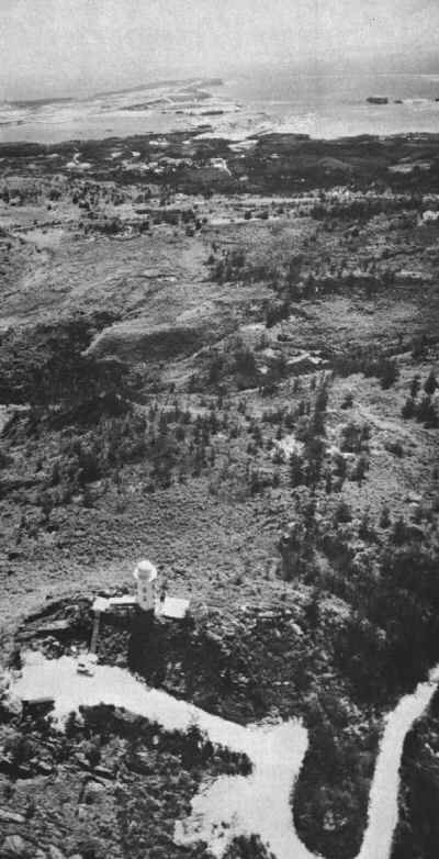 GOOD SPOT-View over island shows section of Guam looking from Mt. Alutom towards Apra
harbor.
GOOD SPOT-View over island shows section of Guam looking from Mt. Alutom towards Apra
harbor.
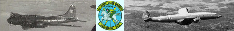
Two weather instrumented aircraft squadrons, one Air Force and one Navy, operate in support of typhoon reconnaissance requirements. They are the Air Force's 56th Weather Reconnaissance Squadron located at Yokota Air Base, Japan, and Navy's Early Warning Squadron One (VW-1), based at the Naval Air Station, Agana, Guam. The 56th recon squadron flies B-50 aircraft and VW-1 flies EC-121Ks (formerly WV-2s).
FWC AND THE Joint Typhoon Warning Center receive weather observations from civilian agencies, land stations, ships at sea, and aircraft of all nations over the Asian and Pacific area. Approximately 1350 weather reports are received daily. Navy and Air Force meteorologists maintain a 24-hour watch to analyze more than 30 weather charts a day based on these reports. From these charts, the duty forecaster prepares warnings and forecasts for transmission by communication personnel.
The reports include the latest known storm position, maximum winds, direction, speed, and probable positions of the storm 12, 24, and 48 hours ahead.
If the typhoon warning center at Guam should become unable to issue warnings, an alternate warning center at Fuchu Air Force Weather Central, Japan, takes over. When typhoon Karen hit Guam in November 1962, the warning responsibility was passed to Fuchu, which responded so quickly that the scheduled warnings were on the air without a break in sequence. The warning center at Guam had accurately forecast Karen's track some 72 hours before Guam was hit, allowing islanders time to make maximum preparations for the big storm.
Other than the FWC at Guam, there are Centrals at Pearl Harbor, Kodiak, and Alameda. Their combined areas of responsibility cover the entire Pacific. FWC Guam is supported by two Fleet Weather Facilities, one at Sangley Point, P. I., and the other at Yokosuka, Japan. The Alameda FWC is supported by a weather facility at San Diego. These are the Pacific FWCs and FWFs. Others are located at Suitland, Md., and Port Lyautey, Morocco. The Suitland FWC is backed by Fleet Weather Facilities at Argentia, Newfoundland; Quonset Point, R. I.; Norfolk, Va.; and Miami, Fla. FWFs at Keflavik, Iceland, and London provide support for FWC, Port Lyautey.
The procedures used by FWC, Guam, are much like those used by all Navy FWCs to protect aircraft, commercial shipping, fishing boats, and the people and property of a warning area, plus our own Navy's ships and stations.